Route des Grandes Alpes: Complete Itinerary and Tips to Prepare Your Trip
- The Route des Grandes Alpes connects Thonon-les-Bains to Nice over approximately 720 km, crossing the main French Alpine passes.
- It can be traveled by car, motorcycle, bicycle, or campervan, each with different paces and constraints.
- The ideal period is from late June to mid-September, when all high-altitude passes are open.
- Allow 4 to 7 days for a comfortable journey, or more if you include extra stops and hikes.
- Good preparation (suitable vehicle, bookings, mapping) helps avoid surprises in the high mountains.
Are you looking to organize your crossing of the Route des Grandes Alpes but don’t know where to start—choosing a vehicle, planning the exact route, or picking the best season? This article provides practical answers: The Route des Grandes Alpes is a premier tourist route linking Lake Geneva to the Mediterranean over approximately 720 km, crossing some of France’s highest Alpine passes, including the Col de l’Iseran (2,770 m) and the Col du Galibier. Whether you plan this journey in a rental car, a campervan, by motorcycle, or by bicycle, you will find a detailed step-by-step route, the best times to ride, and practical advice to avoid common pitfalls (closed passes, fully booked accommodation, or unsuitable vehicles). Head toward Thonon-les-Bains or Nice—the choice of direction is yours.
What exactly is the Route des Grandes Alpes?
The Route des Grandes Alpes (RdGA) is a historic tourist route created in the early 20th century to connect Alpine valleys and develop the burgeoning automobile tourism industry. It links Thonon-les-Bains, on the shores of Lake Geneva, to Nice and the Mediterranean, covering a distance of about 720 km depending on the variations chosen.
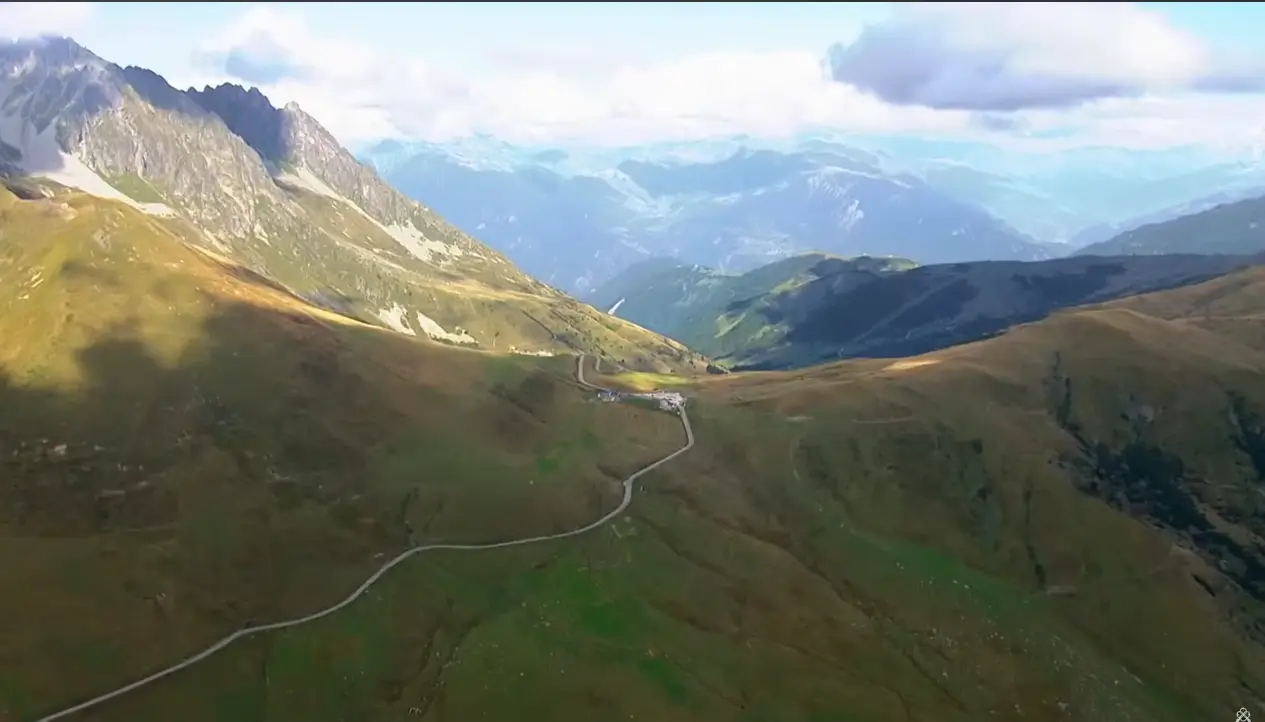
What distinguishes this route from other Alpine itineraries is that it traverses almost all of France’s major mountain passes: Col des Aravis, Cormet de Roselend, Col de l’Iseran (the highest road pass in the French Alps), Col du Galibier, Col d’Izoard, Col de Vars, Col de la Bonette (or its variant via the Cime de la Bonette, the highest paved point in Europe), and finally the Col de Turini before descending toward the French Riviera.
Unlike a highway or a direct route, the RdGA is not designed for speed: it is an itinerary for discovery, punctuated by mountain villages, resorts like Alpe d’Huez or Les Deux Alpes (accessible with a slight detour), and panoramas that justify the trip on their own. The official route is marked and mapped, with a dedicated website offering a summer variant (via the passes) and a winter variant via the valleys, which is passable year-round and called “P’tites Routes du Soleil.”
For those in a rental car, it is important to understand that the route is not a single, rigid line: several alternative itineraries exist depending on the valleys chosen, allowing you to adapt the journey to your available time and personal preferences.
Step-by-step detailed itinerary
The classic route is generally divided into six to eight main stages, from north to south (or vice versa).
Stage 1: Thonon-les-Bains — Megève. Starting at the edge of Lake Geneva, climbing via the Col des Aravis (1,486 m) and arriving in the chic resort of Megève. A good warm-up with gradual elevation gain.
Stage 2: Megève — Bourg-Saint-Maurice. Passing through the Cormet de Roselend, one of the most beautiful passes on the route with views over the Roselend Dam, then descending into the Tarentaise Valley.
Stage 3: Bourg-Saint-Maurice — Val d’Isère — Col de l’Iseran. Climbing toward the highest point of the itinerary, the Col de l’Iseran at 2,770 m altitude, which is generally closed from November to June depending on snow levels.
Stage 4: Maurienne Valley — Col du Galibier — Briançon. This section crosses a striking mineral landscape before reaching the Col du Lautaret and then Briançon, the highest city in France.
Stage 5: Briançon — Col d’Izoard — Guillestre. The Izoard is famous for its lunar landscape, the Casse Déserte, made legendary by the Tour de France.
Stage 6: Guillestre — Col de Vars — Barcelonnette. A gentler stage that crosses the Ubaye Valley.
Stage 7: Barcelonnette — Col de la Bonette — Saint-Étienne-de-Tinée. The variant via the Cime de la Bonette reaches 2,802 m, often cited as the highest paved road in Europe.
Stage 8: Tinée Valley — Col de Turini — Nice. The final descent toward the Mediterranean, passing one of the most legendary passes of the Monte Carlo Rally before arriving on the Côte d’Azur.
Each stage can be extended by an extra night to enjoy a village, a hike, or sites like the Roselend Dam or the Vaujany lakes.
By rental car: Itinerary and practical advice
A car remains the most flexible way to traverse the Route des Grandes Alpes, especially for international tourists or those from other regions who opt for a local rental. The full itinerary is comfortably covered in 4 to 6 days, with a maximum of 100 to 150 km per day: the road is not designed for high mileage, as hairpin turns and switchbacks significantly slow down your average speed.
For this type of trip, prioritize a compact rental car or a sedan with good engine torque rather than a large SUV: mountain passes are narrow, and passing other vehicles can be difficult, particularly on the northern side of the Iseran or the switchbacks of the Bonette. Also, check that your rental agreement explicitly allows high-mountain driving and does not exclude damage related to this type of terrain (some rental companies apply specific exclusions for tracks or unpaved roads, though the RdGA is entirely paved, it is still best to check the terms and conditions).
Another practical tip: gas stations become scarce in the high mountains, especially between Val d’Isère and Bonneval-sur-Arc or in the Ubaye Valley. Always top up your tank before attempting a major pass. Engine braking is also essential on descents; remember to downshift rather than braking continuously, especially with a rental vehicle whose handling you may not be fully familiar with.
Finally, traveling by car allows for many more photo stops and detours to sites like Alpe d’Huez, Les Deux Alpes, or mountain lakes, making it an ideal choice for families or couples wanting to combine driving with local discovery.
By campervan: Itinerary, constraints, and tips
The Route des Grandes Alpes by campervan is increasingly popular with travelers seeking freedom, but it requires more careful planning than a standard car. The first thing to consider is the vehicle’s size: some passes, notably the Izoard and the Bonette, have narrow sections where passing a heavy truck or another campervan can be tricky. A vehicle under 7 meters long and 2.30 m wide is best suited for this route.
The campervan itinerary follows the same general route as the car, but with shorter stages: 80 to 100 km per day is a realistic pace given the time spent at stops and the more cautious driving required for a longer, taller vehicle. Plan for 6 to 8 days for the entire journey.
Overnight parking deserves special attention: many campervan areas exist in the valleys (Bourg-Saint-Maurice, Briançon, Barcelonnette), but they fill up quickly during high season. It is recommended to book ahead or arrive early in the late afternoon between July and August. Wild camping at high altitudes on pass parking lots is generally tolerated for short breaks but not for overnight stays, especially in the regional natural parks crossed by the route (Vanoise, Écrins, Mercantour).
Finally, check your campervan’s weight and load distribution before leaving: long, steep climbs put significant strain on the engine and brakes—a crucial point for a rental vehicle where you are still discovering its performance during climbs and descents.
By motorcycle: Mythical passes from Lake Geneva to the Mediterranean
The Route des Grandes Alpes by motorcycle is undoubtedly the most popular version for enthusiasts of sporty riding, and it has largely contributed to the route’s reputation. For motorcyclists, the most common format spans 5 days, with daily stages of 120 to 160 km including several passes—a pace consistent with the pleasure of riding rather than mileage performance.
Bikers particularly enjoy the Iseran-Galibier-Izoard sequence in the central part of the journey, considered the most spectacular section, as well as the climb to the Cime de la Bonette for its rugged atmosphere and hairpin turns. The road surface is generally good throughout the itinerary, but certain sections, especially on the northern slopes of the passes, can remain wet or gravelly after a storm, which is common in late afternoon during summer.
Proper gear is indispensable: temperature differences between the valley floor and the summit of a pass at over 2,500 m can exceed 15 degrees, even in mid-summer. Layered clothing (base layers, summer and transitional gloves) prevents being caught off guard. It is also recommended to check your tire condition before departure: tire wear from constant tight cornering is faster than on standard roads.
Regarding rentals, several specialized providers offer touring or adventure bikes for this specific route, sometimes including packages with overnight accommodation or mechanical assistance—a real plus for travelers coming from afar.
By bicycle: Between sporting challenge and cycle touring
The Route des Grandes Alpes by bicycle is an official route in its own right, distinct in its practice from the motorized version. The cycling route, structured into 26 stages and variants according to the official website, allows you to adapt the difficulty and duration to your level: experienced cyclists can aim for a condensed 7 to 10-day format, while more relaxed cycle tourists can spread the trip over 2 to 3 weeks, including rest days.
The total elevation gain over the entire route exceeds 15,000 meters, making it one of the most demanding cycling itineraries in Europe. The Col de l’Iseran, at 2,770 m, and the Bonette, at over 2,800 m via the summit, are the highest points of the route and require serious physical preparation.
The use of electric-assist bicycles (e-bikes) has grown significantly in recent years on this route, allowing a wider audience to consider the crossing without aiming for high-performance sports results. However, this requires planning battery autonomy between charging points, as not all mountain villages are equipped with suitable charging stations.
For luggage, cycle tourists have two options: bikepacking with panniers on the bike, which is more autonomous but heavier on climbs, or using a luggage transport service between stages, which is increasingly common along the official route and particularly well-suited for tourists prioritizing comfort over performance.
When is the best time to go?
The choice of season is perhaps the most decisive factor for a successful trip on the Route des Grandes Alpes, regardless of the mode of transport. The optimal window is between late June and mid-September, a period when all high-altitude passes, notably the Iseran and the Bonette, are normally clear of snow and open to traffic.
Outside of this period, several passes close depending on snowfall, forcing travelers to use the valleys via the “P’tites Routes du Soleil” winter variant. Opening dates vary every year based on weather conditions and can generally be checked on the official route website before departure—a check you should never skip if you are aiming for a full crossing via the passes.
July and August guarantee open passes but also bring the highest crowds, with campsites and accommodations filling up, especially around the major cycling passes made famous by the Tour de France. June and September are often considered the best compromise: lighter traffic, pleasant daytime temperatures, and a limited risk of the highest passes closing early or late.
Whichever month you choose, it is better to check the mountain weather the day before each stage rather than relying on general valley forecasts: summer storms form quickly at high altitudes and can make certain sections slippery or dangerous within minutes.
Map and itinerary variants
The official map of the Route des Grandes Alpes distinguishes two main routing options, a distinction worth knowing before booking anything. The first is the historic route via the passes, which follows the itinerary described above and is only passable in summer. The second, named “P’tites Routes du Soleil,” uses the valleys and remains accessible all year round, including in winter, for travelers wishing to discover the region out of season.
Based on this, several regional variants allow you to enrich or shorten the journey depending on your desires. A detour to Alpe d’Huez, accessible from Bourg-d’Oisans, allows you to discover one of the most famous climbs in international cycling, with its 21 numbered hairpins. Similarly, a detour toward Les Deux Alpes, located very close to the main itinerary on the Oisans side, perfectly complements a stage in this sector for lovers of glaciers and high-altitude hiking.
Further south, crossing the Alpes de Haute-Provence around Barcelonnette and the Ubaye Valley offers a softer, more Mediterranean side of the mountains, with light and vegetation that already hint at the Côte d’Azur.
Note to avoid confusion: some travelers search for information on similarly named routes with no direct link, such as the Japanese Alps (a mountain region in Japan) or the Alpes Mancelles (a low-altitude massif in Normandy). The “Route des Grandes Alpes” refers exclusively to the French itinerary linking Lake Geneva to the Mediterranean.
Practical tips for preparing your trip
Beyond choosing your vehicle and the season, a few practical points often make the difference between a smooth journey and a stressful crossing. Booking accommodation well in advance is highly recommended for July and August: the limited capacity of mountain villages fills up quickly, especially around iconic stages like Val d’Isère or Barcelonnette.
Fuel and amenities become scarce on high-altitude sections. It is wise to fill up before every mountain pass climb and to carry water and snacks, as some stretches between villages can extend over 40 km without services.
For navigation, a standard GPS is sufficient for most of the route, but a paper map or an offline app remains useful in areas where mobile networks are absent, which is common at the summits of more isolated passes like Cormet de Roselend or the Bonette.
Finally, build extra time into your schedule: mountain traffic conditions (livestock on the road, seasonal roadworks, heavy cycling traffic in summer) can significantly slow down a stage that was initially planned to be shorter. It is better to have a flexible 6-day itinerary than a rigid 4-day program that leaves no room for the unexpected.
How many days does it take to do the Route des Grandes Alpes by car?
Allow 4 to 6 days to travel the full itinerary by car at a comfortable pace, including stops to enjoy the viewpoints and villages along the way.
What is the highest pass on the Route des Grandes Alpes?
The Col de l’Iseran, at 2,770 m altitude, is the highest road pass on the itinerary, followed by the Col de la Bonette, whose summit variant reaches over 2,800 m.
Can you do the Route des Grandes Alpes in a campervan?
Yes, provided you choose a reasonably sized vehicle (under 7 m) and adapt your pace, with shorter stages than those planned for a standard car.
What is the best time to go on the Route des Grandes Alpes?
The ideal window is from late June to mid-September, a period when high-altitude passes are generally open and passable without the risk of snow.
How many kilometers is the Route des Grandes Alpes?
The full itinerary, from Lake Geneva to the Mediterranean, spans approximately 720 km depending on the route variants chosen.
Is the Route des Grandes Alpes accessible by bike for non-athletes?
Yes, especially thanks to electric-assist bicycles and the option to spread the journey over several weeks with short stages rather than aiming for a purely athletic performance.
Can Alpe d’Huez be included in the Route des Grandes Alpes itinerary?
Yes, a detour from Bourg-d’Oisans allows you to reach Alpe d’Huez and its 21 hairpins, a variant popular with cycling enthusiasts and those seeking views of the Écrins massif.
Is there a winter version of the Route des Grandes Alpes?
Yes, the variant called “P’tites Routes du Soleil” uses the valleys rather than the passes and remains passable year-round, including in winter.
Sources
- Official Route des Grandes Alpes cycling website
- Cycling stages and variants
- Route des Grandes Alpes — Wikipedia
- Detailed motorcycle itinerary for the Route des Grandes Alpes

À découvrir

Best excursions around Paris by car: 12 great ideas
Discover 12 must-see excursions around Paris by car: Versailles, Giverny, Fontainebleau, and more. Ideal family day trips within a 100 km radius.
What to Do in Lyon in 2 Days? Complete Family Itinerary
November 18, 2026
Potholes: Why They Form & How to Repair Them
November 9, 2026